|
|
Antenna Structure Registration 1250440 |
 |
Registration Info | Registration Number: 1250440 |
| File Number: A0475371 |
| FAA Study: 2005-ASO-4514-OE |
| FAA Issue Date: 09/29/2005 |
| Status: Constructed |
| Date Constructed: 01/01/1975 |
| FAA EMI: N |
| NEPA: N |
Structure Info
| Structure Type: 2TA2 |
| Structure Coordinates: 33-37-4.3 N 80-46-52.9 W (NAD 83) |
| Structure Coordinates: 33-37-03.7 N 80-46-53.6 W (Converted to NAD 27) |
| Structure Address: 0.5 Mi Ne Of Sr-s-9-25, Between Us 601 And Shrike Road |
| Structure City: St. Matthews, SC |
| Structure County: Calhoun County |
| Painting & Lighting Info |
FCC Paragraph(s): 1 |
Remarks: PRIOR STUDY 1976-ASO-1251-OE |
Remarks: Continue As Is OM&L = MARKED |
Remarks: PRIOR STUDY 1976-ASO-1251-OE |
Remarks: Continue As Is OM&L = MARKED |
| Elevation Info |
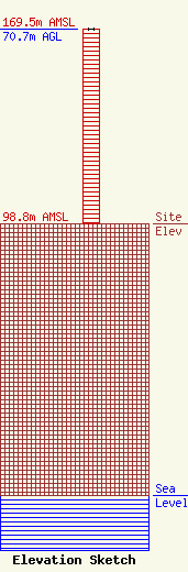
Site Elevation: 98.8 meters (324 ft) |
| Height of Structure: 70.7 meters (232 feet) |
| Overall Height Above Ground: 70.7 meters (232 feet) |
| Overall Height Above Mean Sea Level: 169.5 meters (556 feet) |
| Owner Info | Miller Communications, Inc.
1269
Sumter, SC 29151-1269
(803) 775-2321
harold@miller.fm |
| Contact Info | Graham Brock, Inc.
24466
St. Simons Island, GA 31522-7466
Marilyn Matheny
(912) 638-8028
marilyn@grahambrock.com |
