|
|
Antenna Structure Registration 1250714 |
 |
Registration Info | Registration Number: 1250714 |
| File Number: A0476502 |
| FAA Study: 2005-ASW-5424-OE |
| FAA Issue Date: 10/19/2005 |
| Status: Granted |
| NEPA: N |
Structure Info
| Structure Type: TOWER |
| Structure Coordinates: 35-6-47.5 N 92-25-17.0 W (NAD 83) |
| Structure Coordinates: 35-06-47.2 N 92-25-16.4 W (Converted to NAD 27) |
| Structure Address: Highway 65 At Hilltop Near Conway City Limit |
| Structure City: Conway, AR |
| Structure County: Faulkner County |
| Painting & Lighting Info |
FAA Circular #: |
FAA Chapters: NONE |
Remarks: Removed expiration date from determination. Scenario 1./jjs/case#635066 |
| Elevation Info |
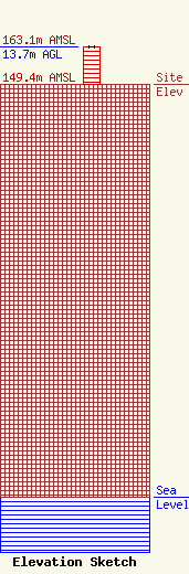
Site Elevation: 149.4 meters (490 ft) |
| Height of Structure: 13.7 meters (45 feet) |
| Overall Height Above Ground: 13.7 meters (45 feet) |
| Overall Height Above Mean Sea Level: 163.1 meters (535 feet) |
| Owner Info | CRAIN MEDIA GROUP, LLC
200 SOUTH COMMERCE, SUITE 702
LITTLE ROCK, AR 72201
(501) 537-0720
|
