|
|
Antenna Structure Registration 1251178 |
 |
Registration Info | Registration Number: 1251178 |
| File Number: A1206911 |
| FAA Study: 2005-AGL-1256-OE |
| FAA Issue Date: 06/29/2005 |
| Status: Constructed |
| Date Constructed: 12/05/2006 |
| FAA EMI: N |
| NEPA: N |
Structure Info
| Structure Type: TOWER |
| Structure Coordinates: 45-38-29.1 N 89-26-53.1 W (NAD 83) |
| Structure Coordinates: 45-38-29.3 N 89-26-52.6 W (Converted to NAD 27) |
| Structure Address: 3616 Highway 47 North |
| Structure City: Rhinelander, WI |
| Structure County: Oneida County |
| Painting & Lighting Info |
FAA Chapters: NONE |
Remarks: Removed expiration date from determination. Scenario 1./jjs/case#635066 |
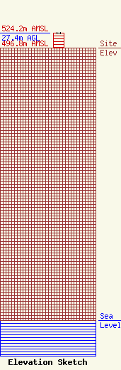
| Elevation Info |
Site Elevation: 496.8 meters (1630 ft) |
| Height of Structure: 27.4 meters (90 feet) |
| Overall Height Above Ground: 27.4 meters (90 feet) |
| Overall Height Above Mean Sea Level: 524.2 meters (1720 feet) |
| Owner Info | TVT I, LLC
495 Tennessee Street, Suite # 152
Memphis, TN 38103
(901) 277-4083
royal@towerventures.com |
| Contact Info | TVT I, LLC
495 Tennessee Street, Suite # 152
Memphis, TN 38103
Craig Royal
(901) 277-4083
royal@towerventures.com |
