|
|
Antenna Structure Registration 1251303 |
 |
Registration Info | Registration Number: 1251303 |
| File Number: A0490255 |
| FAA Study: 2005-ASO-6060-OE |
| FAA Issue Date: 12/09/2005 |
| Status: Constructed |
| Date Constructed: 04/01/1994 |
| FAA EMI: N |
| NEPA: N |
Structure Info
| Structure Type: TOWER |
| Structure Coordinates: 36-31-7.5 N 89-5-41.4 W (NAD 83) |
| Structure Coordinates: 36-31-07.3 N 89-05-41.2 W (Converted to NAD 27) |
| Structure Address: 0.85 Miles Ese Of The Intersection Of Sr 116 And Sr 166 |
| Structure City: Cayce, KY |
| Structure County: Fulton County |
| Painting & Lighting Info |
FAA Circular #: 70/7460-1H |
FAA Chapters: 3, 4, 5, 13 |
Remarks: PRIOR STUDY 1991-ASO-1374-OE |
Remarks: OM&L to remain the same as prior study = PAINT/RED LIGHTS |
Remarks: PRIOR STUDY 1991-ASO-1374-OE |
Remarks: OM&L to remain the same as prior study = PAINT/RED LIGHTS |
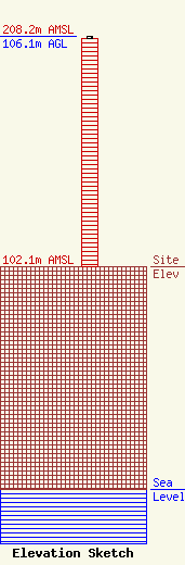
| Elevation Info |
Site Elevation: 102.1 meters (335 ft) |
| Height of Structure: 105.2 meters (345 feet) |
| Overall Height Above Ground: 106.1 meters (348 feet) |
| Overall Height Above Mean Sea Level: 208.2 meters (683 feet) |
| Owner Info | Thunderbolt Broadcasting Company
318
Martin, TN 38237
(731) 587-9526
ptinkle@crunet.com |
| Contact Info | Womble Carlyle Sandridge & Rice, PLLC
1401 I Street, NW, 7th Floor
Washington, DC 20005
John Garziglia
(202) 857-4455
jgarziglia@wcsr.com |
