|
|
Antenna Structure Registration 1251390 |
 |
Registration Info | Registration Number: 1251390 |
| File Number: A0485236 |
| FAA Study: 2005-ASO-6091-OE |
| FAA Issue Date: 12/08/2005 |
| Status: Granted |
| FAA EMI: N |
| NEPA: N |
Structure Info
| Structure Type: 3TA2 |
| Structure Coordinates: 26-4-42.5 N 80-13-2.4 W (NAD 83) |
| Structure Coordinates: 26-04-41.2 N 80-13-03.2 W (Converted to NAD 27) |
| Structure Address: West Side Of Fl Turnpike, 0.9 Mi S Of I-595 |
| Structure City: Davie, FL |
| Structure County: Broward County |
| Painting & Lighting Info |
FAA Chapters: NONE |
| Elevation Info |
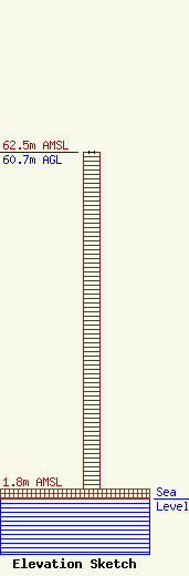
Site Elevation: 1.8 meters (6 ft) |
| Height of Structure: 60.7 meters (199 feet) |
| Overall Height Above Ground: 60.7 meters (199 feet) |
| Overall Height Above Mean Sea Level: 62.5 meters (205 feet) |
| Owner Info | ALLIANCE BROADCASTING, INC.
1510 N.E 162ND STREET
MIAMI, FL 33162
(305) 944-8383
|
| Contact Info | Leventhal Senter & Lerman PLLC
2000 K Street, NW, Ste. 600
Washington, DC 20006-1809
Brian Madden
(202) 429-8970
bmadden@lsl-law.com |
