|
|
Antenna Structure Registration 1251792 |
 |
Registration Info | Registration Number: 1251792 |
| File Number: A0804147 |
| FAA Study: 2005-ASW-5995-OE |
| FAA Issue Date: 11/16/2005 |
| Status: Constructed |
| Date Constructed: 05/02/2006 |
| FAA EMI: N |
| NEPA: N |
Structure Info
| Structure Type: TOWER |
| Structure Coordinates: 35-17-20.5 N 91-46-17.5 W (NAD 83) |
| Structure Coordinates: 35-17-20.2 N 91-46-17.0 W (Converted to NAD 27) |
| Structure Address: Oak Forest Road And Highway 16 |
| Structure City: Searcy, AR |
| Structure County: White County |
| Painting & Lighting Info |
FAA Circular #: 70/7460-1K |
FAA Chapters: 3, 4, 5, 12 |
Remarks: Removed expiration date from determination. Scenario 1./jjs/case#635066 |
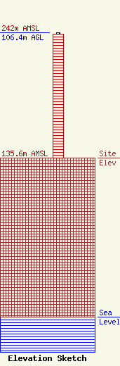
| Elevation Info |
Site Elevation: 135.6 meters (445 ft) |
| Height of Structure: 105.2 meters (345 feet) |
| Overall Height Above Ground: 106.4 meters (349 feet) |
| Overall Height Above Mean Sea Level: 242 meters (794 feet) |
| Owner Info | CRAIN MEDIA GROUP, LLC
5980 WADLEY ROAD
SHERWOOD, AR 72120
(501) 542-5000
scott@graymediacorp.com |
| Contact Info | CRAIN MEDIA GROUP, LLC
5980 WADLEY ROAD
SHERWOOD, AR 72120
(501) 542-5000
scott@graymediacorp.com |
