|
|
Antenna Structure Registration 1252126 |
 |
Registration Info | Registration Number: 1252126 |
| File Number: A0492137 |
| FAA Study: 2005-ACE-3034-OE |
| FAA Issue Date: 01/06/2006 |
| Status: Granted |
| NEPA: N |
Structure Info
| Structure Type: TOWER |
| Structure Coordinates: 38-3-22.0 N 97-44-44.0 W (NAD 83) |
| Structure Coordinates: 38-03-22.0 N 97-44-42.8 W (Converted to NAD 27) |
| Structure Address: 4.6 Miles W.n.w. Of Burrton |
| Structure City: Burrton, KS |
| Structure County: Reno County |
| Painting & Lighting Info |
FAA Circular #: 70/7460-1K |
FAA Chapters: 3, 4, 5, 12 |
Remarks: Removed expiration and final dates from determination. Scenario 2./jjs/case#635066 |
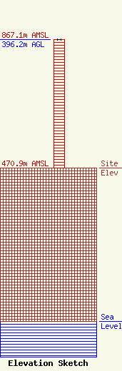
| Elevation Info |
Site Elevation: 470.9 meters (1545 ft) |
| Height of Structure: 396.2 meters (1300 feet) |
| Overall Height Above Ground: 396.2 meters (1300 feet) |
| Overall Height Above Mean Sea Level: 867.1 meters (2845 feet) |
| Owner Info | Hutchinson Community College
815 W. Walnut Street
Hutchinson, KS 67501
(620) 662-6646
dhorning@radiokansas.org |
| Contact Info | Doug Vernier Telecommunications Consultants
721 West 1st Street, Suite A
Cedar Falls, IA 50613
Doug Vernier
(319) 266-8402
dvernier@v-soft.com |
