|
|
Antenna Structure Registration 1255800 |
 |
Registration Info | Registration Number: 1255800 |
| File Number: A0521280 |
| FAA Study: 2006-AGL-3396-OE |
| FAA Issue Date: 08/23/2006 |
| Status: Constructed |
| Date Constructed: 10/24/2006 |
| FAA EMI: N |
| NEPA: N |
Structure Info
| Structure Type: TOWER |
| Structure Coordinates: 40-2-50.2 N 83-3-42.3 W (NAD 83) |
| Structure Coordinates: 40-02-50.0 N 83-03-42.6 W (Converted to NAD 27) |
| Structure Address: 4401 Carriage Hill Lane |
| Structure City: Columbus, OH |
| Structure County: Franklin County |
| Painting & Lighting Info |
FAA Circular #: 70/7460-1K |
FAA Chapters: 3, 4, 5, 12 |
Remarks: Removed expiration and final dates from determination. Scenario 2./jjs/case#635066 |
Remarks: PRIOR STUDY 1997-AGL-2674-OE |
Remarks: Removed expiration and final dates from determination. Scenario 2./jjs/case#635066 |
Remarks: PRIOR STUDY 1997-AGL-2674-OE |
| Elevation Info |
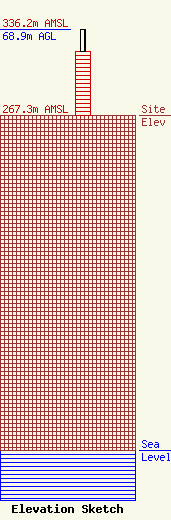
Site Elevation: 267.3 meters (877 ft) |
| Height of Structure: 51.2 meters (168 feet) |
| Overall Height Above Ground: 68.9 meters (226 feet) |
| Overall Height Above Mean Sea Level: 336.2 meters (1103 feet) |
| Owner Info | Franklin Communications, Inc.
73 Kercheval Avenue, Suite 201
Grosse Pointe Farms, MI 48236
(313) 886-7070
gurbiel@sagacom.com |
| Contact Info | Smithwick & Belendiuk, P.C.
5028 Wisconsin Avenue, NW, Ste. 301
Washington, DC 20016
Gary Smithwick
(202) 363-4560
gsmithwick@fccworld.com |
