|
|
Antenna Structure Registration 1256202 |
 |
Registration Info | Registration Number: 1256202 |
| File Number: A1310070 |
| FAA Study: 2006-ASO-5313-OE |
| FAA Issue Date: 11/06/2006 |
| Status: Constructed |
| Date Constructed: 01/20/2007 |
| FAA EMI: Y |
| NEPA: N |
Structure Info
| Structure Type: TOWER |
| Structure Coordinates: 27-27-29.1 N 82-32-13.9 W (NAD 83) |
| Structure Coordinates: 27-27-28.0 N 82-32-14.6 W (Converted to NAD 27) |
| Structure Address: 47th Terrace East |
| Structure City: Bradenton, FL |
| Structure County: Manatee County |
| Painting & Lighting Info |
FAA Circular #: 70/7460-1K |
FAA Chapters: 4, 8, 12 |
Remarks: Removed expiration date from determination. Scenario 1./jjs/case#635066 |
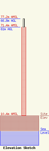
| Elevation Info |
Site Elevation: 10.4 meters (34 ft) |
| Height of Structure: 61 meters (200 feet) |
| Overall Height Above Ground: 66.8 meters (219 feet) |
| Overall Height Above Mean Sea Level: 77.2 meters (253 feet) |
| Owner Info | Manatee County Government
1112 Manatee Ave West
Bradenton, FL 34205
(941) 748-4501
john.hamel@mymanatee.org |
| Contact Info | Manatee County Government
1801 5th Street West
Bradenton, FL 34205
John Hamel
(941) 773-2431
john.hamel@mymanatee.org |
