|
|
Antenna Structure Registration 1256756 |
 |
Registration Info | Registration Number: 1256756 |
| File Number: A1135085 |
| FAA Study: 2006-AEA-5169-OE |
| FAA Issue Date: 12/27/2006 |
| Status: Constructed |
| Date Constructed: 01/12/2007 |
| FAA EMI: N |
| NEPA: N |
Structure Info
| Structure Type: TOWER |
| Structure Coordinates: 38-13-47.8 N 80-32-48.1 W (NAD 83) |
| Structure Coordinates: 38-13-47.4 N 80-32-48.8 W (Converted to NAD 27) |
| Structure Address: 3 Miles North Of Richwood On Horse Ridge |
| Structure City: Richwood, WV |
| Structure County: Nicholas County |
| Painting & Lighting Info |
FAA Chapters: NONE |
Remarks: Removed expiration date from determination. Scenario 1./jjs/case#635066 |
| Elevation Info |
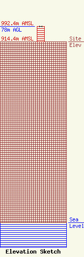
Site Elevation: 914.4 meters (3000 ft) |
| Height of Structure: 78 meters (256 feet) |
| Overall Height Above Ground: 78 meters (256 feet) |
| Overall Height Above Mean Sea Level: 992.4 meters (3256 feet) |
| Owner Info | Summit Media Inc.
120 Main Street
Sutton, WV 26601
(304) 765-7373
al@summitmediawv.com |
| Contact Info | Summit Media Inc.
120 Main Street
Sutton, WV 26601
Nunzio Sergi
(304) 765-7373
al@summitmediawv.com |
