|
|
Antenna Structure Registration 1257001 |
 |
Registration Info | Registration Number: 1257001 |
| File Number: A0734486 |
| FAA Study: 2006-AGL-9463-OE |
| FAA Issue Date: 01/29/2007 |
| Status: Constructed |
| Date Constructed: 07/01/2008 |
| FAA EMI: N |
| NEPA: N |
Structure Info
| Structure Type: TOWER |
| Structure Coordinates: 41-42-32.5 N 86-9-49.9 W (NAD 83) |
| Structure Coordinates: 41-42-32.3 N 86-09-49.9 W (Converted to NAD 27) |
| Structure Address: 1301 East Douglas Road |
| Structure City: Mishawaka, IN |
| Structure County: St. Joseph County |
| Painting & Lighting Info |
FAA Chapters: NONE |
| Elevation Info |
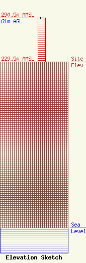
Site Elevation: 229.5 meters (753 ft) |
| Height of Structure: 61 meters (200 feet) |
| Overall Height Above Ground: 61 meters (200 feet) |
| Overall Height Above Mean Sea Level: 290.5 meters (953 feet) |
| Owner Info | WSBT, Inc.
1301 East Douglas Road
Mishawaka, IN 46545
(574) 233-3141
hale@wsbt.com |
| Contact Info | The Law Offices of Jack N. Goodman
601 13th Street, NW
Washington, DC 20005
Jack Goodman
(202) 683-2042
jack@jackngoodman.com |
