|
|
Antenna Structure Registration 1257822 |
 |
Registration Info | Registration Number: 1257822 |
| File Number: A0570448 |
| FAA Study: 2007-ASO-6886-OE |
| FAA Issue Date: 12/03/2007 |
| Status: Constructed |
| Date Constructed: 11/28/2007 |
| FAA EMI: N |
| NEPA: N |
Structure Info
| Structure Type: TOWER |
| Structure Coordinates: 38-51-46.2 N 84-37-33.9 W (NAD 83) |
| Structure Coordinates: 38-51-46.0 N 84-37-34.1 W (Converted to NAD 27) |
| Structure Address: 183 Beaver Road |
| Structure City: Walton, KY |
| Structure County: Boone County |
| Painting & Lighting Info |
FAA Circular #: 70/7460-1K |
FAA Chapters: 4, 8, 12 |
Remarks: PRIOR STUDY 2007-ASO-477-OE |
| Elevation Info |
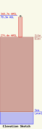
Site Elevation: 270.4 meters (887 ft) |
| Height of Structure: 73.2 meters (240 feet) |
| Overall Height Above Ground: 78.3 meters (257 feet) |
| Overall Height Above Mean Sea Level: 348.7 meters (1144 feet) |
| Owner Info | KENTUCKY, COMMONWEALTH OF DBA = KY EMERGENCY WARNING SYSTEM KEWS
100 Minuteman Pky Building 101
Frankfort, KY 40601
(502) 564-5397
william.hays@ky.gov |
