|
|
Antenna Structure Registration 1257904 |
 |
Registration Info | Registration Number: 1257904 |
| File Number: A0594696 |
| FAA Study: 2007-AGL-2025-OE |
| FAA Issue Date: 04/05/2007 |
| Status: Constructed |
| Date Constructed: 06/01/2007 |
| FAA EMI: N |
| NEPA: N |
Structure Info
| Structure Type: TOWER |
| Structure Coordinates: 43-57-12.0 N 86-24-47.6 W (NAD 83) |
| Structure Coordinates: 43-57-12.0 N 86-24-47.3 W (Converted to NAD 27) |
| Structure Address: 5399 West Wallace Lane |
| Structure City: Ludington, MI |
| Structure County: Mason County |
| Painting & Lighting Info |
FAA Chapters: NONE |
Remarks: Removed expiration date from determination. Scenario 1./jjs/case#635066 |
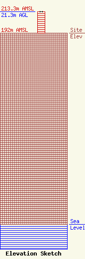
| Elevation Info |
Site Elevation: 192 meters (630 ft) |
| Height of Structure: 21.3 meters (70 feet) |
| Overall Height Above Ground: 21.3 meters (70 feet) |
| Overall Height Above Mean Sea Level: 213.3 meters (700 feet) |
| Owner Info | Synergy Media, Inc
941
Pentwater, MI 49449-0941
(231) 869-7402
|
| Contact Info | Carl E. Smith Consulting Engineers
2324 N. Cleveland-Massillon Rd.
807
Bath, OH 44210-0807
Roy Stype
(330) 659-4440
|
