|
|
Antenna Structure Registration 1258825 |
 |
Registration Info | Registration Number: 1258825 |
| File Number: A1190902 |
| FAA Study: 2007-ASW-3999-OE |
| FAA Issue Date: 05/29/2007 |
| Status: Constructed |
| Date Constructed: 06/01/1980 |
| FAA EMI: N |
| NEPA: N |
Structure Info
| Structure Type: TOWER |
| Structure Coordinates: 34-36-12.7 N 98-23-54.2 W (NAD 83) |
| Structure Coordinates: 34-36-12.4 N 98-23-53.0 W (Converted to NAD 27) |
| Structure Address: 626 S.w. D Avenue |
| Structure City: Lawton, OK |
| Structure County: Comanche County |
| Painting & Lighting Info |
FAA Chapters: NONE |
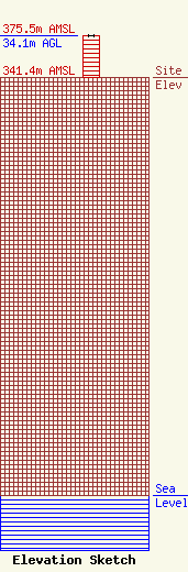
| Elevation Info |
Site Elevation: 341.4 meters (1120 ft) |
| Height of Structure: 34.1 meters (112 feet) |
| Overall Height Above Ground: 34.1 meters (112 feet) |
| Overall Height Above Mean Sea Level: 375.5 meters (1232 feet) |
| Owner Info | Townsquare Media Lawton, LLC
1 Manhattanville Road
Purchase, NY 10577
(203) 861-0900
fcccontact@townsquaremedia.com |
| Contact Info | Townsquare Media Lawton, LLC
1 Manhattanville Road
Purchase, NY 10577
(203) 861-0900
fcccontact@townsquaremedia.com |
