|
|
Antenna Structure Registration 1259450 |
 |
Registration Info | Registration Number: 1259450 |
| File Number: A0831066 |
| FAA Study: 2007-AWP-3192-OE |
| FAA Issue Date: 07/02/2007 |
| Status: Cancelled |
| FAA EMI: N |
| NEPA: N |
Structure Info
| Structure Type: TOWER |
| Structure Coordinates: 34-0-19.0 N 118-21-47.3 W (NAD 83) |
| Structure Coordinates: 34-00-19.0 N 118-21-44.0 W (Converted to NAD 27) |
| Structure Address: Atop Baldwin Hill, Los Angeles County |
| Structure City: Ladera Heights, CA |
| Structure County: Los Angeles County |
| Painting & Lighting Info |
FAA Chapters: NONE |
| Elevation Info |
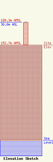
Site Elevation: 152.7 meters (501 ft) |
| Height of Structure: 36.6 meters (120 feet) |
| Overall Height Above Ground: 36.6 meters (120 feet) |
| Overall Height Above Mean Sea Level: 189.3 meters (621 feet) |
| Owner Info | Southern Pacific Towers, LLC
2605 Thomas Drive
Panama City Beach, FL 32408
(850) 230-8331
bparker@durdenent.com |
| Contact Info | Pillsbury Winthrop Shaw Pittman LLP
2300 N Street, NW
Washington, DC 20037-1122
Lewis Paper
(202) 663-8184
lew.paper@pillsburylaw.com |
