|
|
Antenna Structure Registration 1261263 |
 |
Registration Info | Registration Number: 1261263 |
| File Number: A0626696 |
| FAA Study: 2007-ACE-4601-OE |
| FAA Issue Date: 12/20/2007 |
| Status: Granted |
| FAA EMI: N |
| NEPA: N |
Structure Info
| Structure Type: TOWER |
| Structure Coordinates: 37-41-18.2 N 95-28-12.9 W (NAD 83) |
| Structure Coordinates: 37-41-18.0 N 95-28-12.0 W (Converted to NAD 27) |
| Structure Address: 702 N. Plumer Street In Chanute, Kansas |
| Structure City: Chanute, KS |
| Structure County: Neosho County |
| Painting & Lighting Info |
FAA Chapters: NONE |
Remarks: PRIOR STUDY 1996-ACE-246-OE |
| Elevation Info |
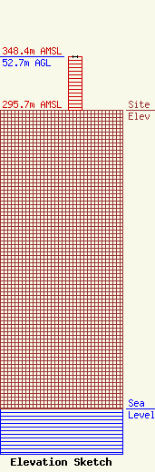
Site Elevation: 295.7 meters (970 ft) |
| Height of Structure: 52.7 meters (173 feet) |
| Overall Height Above Ground: 52.7 meters (173 feet) |
| Overall Height Above Mean Sea Level: 348.4 meters (1143 feet) |
| Owner Info | My Town Media, Inc.
250 N. Water, Suite 300
Wichita, KS 67202
(316) 267-3241
bwachter@wntlaw.kscoxmail.com |
