|
|
Antenna Structure Registration 1265851 |
 |
Registration Info | Registration Number: 1265851 |
| File Number: A0656575 |
| FAA Study: 2008-ASO-5537-OE |
| FAA Issue Date: 10/23/2008 |
| Status: Constructed |
| Date Constructed: 12/30/2008 |
| FAA EMI: N |
| NEPA: N |
Structure Info
| Structure Type: TOWER |
| Structure Coordinates: 34-29-52.8 N 81-32-53.9 W (NAD 83) |
| Structure Coordinates: 34-29-52.3 N 81-32-54.5 W (Converted to NAD 27) |
| Structure Address: Maybinton Road, 3.5 Mi E Of Whitmire, Sc |
| Structure City: Whitmire, SC |
| Structure County: Union County |
| Painting & Lighting Info |
FAA Circular #: 70/7460-1K |
FAA Chapters: 4, 6, 12 |
Remarks: Removed expiration date from determination. Scenario 1./jjs/case#635066 |
Remarks: PRIOR STUDY 2008-ASO-4698-OE |
| Elevation Info |
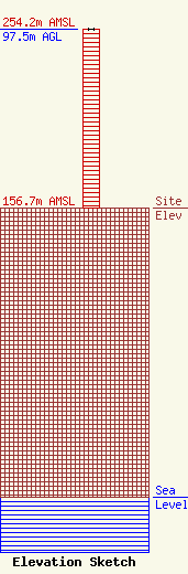
Site Elevation: 156.7 meters (514 ft) |
| Height of Structure: 97.5 meters (320 feet) |
| Overall Height Above Ground: 97.5 meters (320 feet) |
| Overall Height Above Mean Sea Level: 254.2 meters (834 feet) |
| Info |
