|
|
Antenna Structure Registration 1266941 |
 |
Registration Info | Registration Number: 1266941 |
| File Number: A0917447 |
| FAA Study: 2006-AEA-5511-OE |
| FAA Issue Date: 01/31/2007 |
| Status: Constructed |
| Date Constructed: 11/15/2008 |
| FAA EMI: N |
| NEPA: N |
Structure Info
| Structure Type: TOWER |
| Structure Coordinates: 44-45-53.1 N 73-35-14.5 W (NAD 83) |
| Structure Coordinates: 44-45-53.0 N 73-35-16.0 W (Converted to NAD 27) |
| Structure Address: Top Of Beartown Ski Area |
| Structure City: Beekmantown, NY |
| Structure County: Clinton County |
| Painting & Lighting Info |
FAA Chapters: NONE |
| Elevation Info |
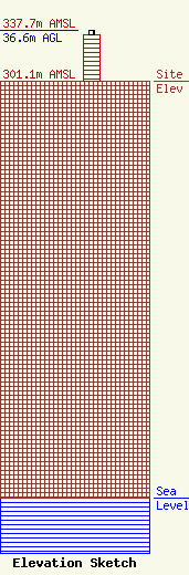
Site Elevation: 301.1 meters (988 ft) |
| Height of Structure: 33.5 meters (110 feet) |
| Overall Height Above Ground: 36.6 meters (120 feet) |
| Overall Height Above Mean Sea Level: 337.7 meters (1108 feet) |
| Owner Info | Independent Digital & Wireless, Inc.
288 South RIver Road
Bedford, NH 03110
(603) 668-9999
lisab@nebcast.com |
| Contact Info | Independent Digital & Wireless, Inc.
288 South River Road
Bedford, NH 03110
Lisa Burgess
(603) 668-9999
lisab@nebcast.com |
