|
|
Antenna Structure Registration 1267055 |
 |
Registration Info | Registration Number: 1267055 |
| File Number: A1326711 |
| FAA Study: 2021-ANM-4674-OE |
| FAA Issue Date: 07/23/2021 |
| Status: Constructed |
| Date Constructed: 08/11/2025 |
| NEPA: N |
Structure Info
| Structure Type: LTOWER |
| Structure Coordinates: 43-57-22.1 N 124-4-29.9 W (NAD 83) |
| Structure Coordinates: 43-57-22.7 N 124-04-25.5 W (Converted to NAD 27) |
| Structure Address: Approx 2 Mi E Of Hwy 101 S Edge Of Town |
| Structure City: Glenada, OR |
| Structure County: Lane County |
| Painting & Lighting Info |
FAA Circular #: 70/7460-1G |
FAA Chapters: 3, 4, 5, 9 |
Remarks: OM&L to remain the same as prior studies = PAINT/RED LIGHTS |
Remarks: PRIOR STUDIES 90-ANM-0557-OE / 2006-ANM-936-OE |
Remarks: OM&L to remain the same as prior studies = PAINT/RED LIGHTS |
Remarks: PRIOR STUDIES 90-ANM-0557-OE / 2006-ANM-936-OE |
| Elevation Info |
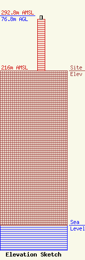
Site Elevation: 216 meters (709 ft) |
| Height of Structure: 72.2 meters (237 feet) |
| Overall Height Above Ground: 76.8 meters (252 feet) |
| Overall Height Above Mean Sea Level: 292.8 meters (961 feet) |
| Owner Info | West Lane Translator Inc.
91
Florence, OR 97439
(541) 521-9529
dennis.hunt@westlanetv.org |
| Contact Info | West Lane Translator, Inc.
3044 Yolanda Ave
Springfield, OR 97477
Dennis Hunt
(541) 521-9529
dennis.hunt@westlanetv.org |
