|
|
Antenna Structure Registration 1267825 |
 |
Registration Info | Registration Number: 1267825 |
| File Number: A0630024 |
| FAA Study: 96-AEA-1271-OE |
| FAA Issue Date: 09/18/1996 |
| Status: Granted |
| NEPA: N |
Structure Info
| Structure Type: BANT |
| Structure Coordinates: 43-9-23.0 N 77-36-42.0 W (NAD 83) |
| Structure Coordinates: 43-09-22.8 N 77-36-43.0 W (Converted to NAD 27) |
| Structure Address: 28 East Main Street |
| Structure City: Rochester, NY |
| Structure County: Monroe County |
| Painting & Lighting Info |
FAA Circular #: 70/7460-1J |
FAA Chapters: 4, 8, 13 |
| Elevation Info |
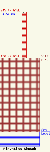
Site Elevation: 150.9 meters (495 ft) |
| Height of Structure: 94 meters (308 feet) |
| Overall Height Above Ground: 94.5 meters (310 feet) |
| Overall Height Above Mean Sea Level: 245.4 meters (805 feet) |
| Owner Info | FIRST FEDERAL PLAZA
28 EAST MAIN STREET, SUITE 1530
ROCHESTER, NY 14614
(585) 546-8111
CHILL@IGORDON.COM |
