|
|
Antenna Structure Registration 1268097 |
 |
Registration Info | Registration Number: 1268097 |
| File Number: A1063770 |
| FAA Study: 2009-ANM-653-OE |
| FAA Issue Date: 04/21/2009 |
| Status: Constructed |
| Date Constructed: 12/01/1959 |
| FAA EMI: N |
| NEPA: N |
Structure Info
| Structure Type: TOWER |
| Structure Coordinates: 44-0-9.0 N 123-6-58.3 W (NAD 83) |
| Structure Coordinates: 44-00-09.6 N 123-06-54.0 W (Converted to NAD 27) |
| Structure Address: 4575 Blanton Road, Eugene, Oregon 97405 |
| Structure City: Eugene, OR |
| Structure County: Lane County |
| Painting & Lighting Info |
FAA Chapters: NONE |
Remarks: PRIOR STUDY 1997-ANM-1528-OE |
| Elevation Info |
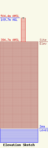
Site Elevation: 394.7 meters (1295 ft) |
| Height of Structure: 107.8 meters (354 feet) |
| Overall Height Above Ground: 109.7 meters (360 feet) |
| Overall Height Above Mean Sea Level: 504.4 meters (1655 feet) |
| Owner Info | Sinclair Eugene Licensee, LLC
Pillsbury Winthrop Shaw Pittman LLP
Washington, DC 20036
(202) 663-8195
miles.mason@pillsburylaw.com |
| Contact Info | Sinclair Eugene Licensee, LLC
Pillsbury Winthrop Shaw Pittman LLP
Washington, DC 20036
(202) 663-8195
miles.mason@pillsburylaw.com |
