|
|
Antenna Structure Registration 1268738 |
 |
Registration Info | Registration Number: 1268738 |
| File Number: A0652736 |
| FAA Study: 2009-AEA-1314-OE |
| FAA Issue Date: 05/22/2009 |
| Status: Constructed |
| Date Constructed: 10/01/2009 |
| FAA EMI: N |
| NEPA: N |
Structure Info
| Structure Type: TOWER |
| Structure Coordinates: 37-21-32.9 N 79-9-31.3 W (NAD 83) |
| Structure Coordinates: 37-21-32.4 N 79-09-32.2 W (Converted to NAD 27) |
| Structure Address: Candlers Mountain |
| Structure City: Flat Creek District, VA |
| Structure County: Lynchburg city |
| Painting & Lighting Info |
FAA Chapters: NONE |
Remarks: PRIOR STUDY 2007-AEA-3515-OE |
Remarks: Removed expiration date from determination. Scenario 1./jjs/case#635066 |
| Elevation Info |
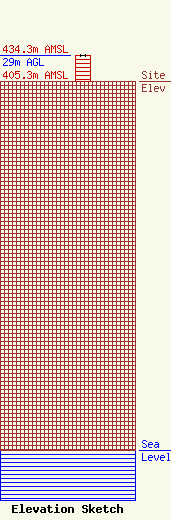
Site Elevation: 405.3 meters (1330 ft) |
| Height of Structure: 29 meters (95 feet) |
| Overall Height Above Ground: 29 meters (95 feet) |
| Overall Height Above Mean Sea Level: 434.3 meters (1425 feet) |
| Owner Info | Liberty University, Inc.
1971 University Boulevard
Lynchburg, VA 24502-2269
(434) 582-2737
msridgew@liberty.edu |
