|
|
Antenna Structure Registration 1269064 |
 |
Registration Info | Registration Number: 1269064 |
| File Number: A1091577 |
| FAA Study: 2008-AEA-2147-OE |
| FAA Issue Date: 05/27/2008 |
| Status: Dismantled |
| Date Constructed: 09/20/2009 |
| FAA EMI: N |
| NEPA: N |
Structure Info
|
| Structure Coordinates: 39-4-13.8 N 80-31-13.2 W (NAD 83) |
| Structure Coordinates: 39-04-13.5 N 80-31-13.9 W (Converted to NAD 27) |
| Structure Address: 1 3/4 Mile North Of Rt.33 West On Keith Fork Rd. |
| Structure City: Waldeck, WV |
| Structure County: Lewis County |
| Painting & Lighting Info |
FAA Chapters: NONE |
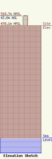
| Elevation Info |
Site Elevation: 476.1 meters (1562 ft) |
| Height of Structure: 42.6 meters (140 feet) |
| Overall Height Above Ground: 42.6 meters (140 feet) |
| Overall Height Above Mean Sea Level: 518.7 meters (1702 feet) |
| Owner Info | LLOYD Hoff Holding Corp DBA Portapage
108 Industrial Lane
250
Millwood, WV 25262
(304) 273-2790
ben@lloydselectronics.com |
| Contact Info | LLoyds Electronics
2100 7th. Avenue
Charleston, WV 25312
Joe Hunter
(304) 720-1562
hunter@lloydselectronics.com |
