|
|
Antenna Structure Registration 1269175 |
 |
Registration Info | Registration Number: 1269175 |
| File Number: A1222816 |
| FAA Study: 2021-AGL-34090-OE |
| FAA Issue Date: 08/22/2022 |
| Status: Constructed |
| Date Constructed: 07/27/2009 |
| NEPA: N |
Structure Info
| Structure Type: GTOWER |
| Structure Coordinates: 45-17-20.1 N 93-14-15.7 W (NAD 83) |
| Structure Coordinates: 45-17-20.2 N 93-14-14.9 W (Converted to NAD 27) |
| Structure Address: 1307 Crosstown Blvd. (mn22235-a) |
| Structure City: Andover, MN |
| Structure County: Anoka County |
| Painting & Lighting Info |
FAA Circular #: 70/7460-1K |
FAA Chapters: 4, 8, 12 |
Remarks: OM&L to remain the same as prior study = A MED-DUAL SYSTEM |
Remarks: PRIOR STUDY 2017-AGL-21460-OE |
Remarks: OM&L to remain the same as prior study = A MED-DUAL SYSTEM |
Remarks: PRIOR STUDY 2017-AGL-21460-OE |
| Elevation Info |
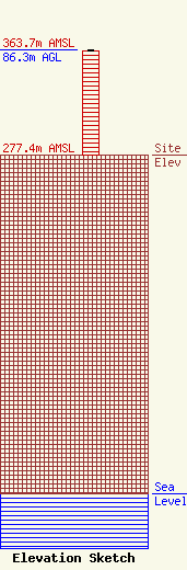
Site Elevation: 277.4 meters (910 ft) |
| Height of Structure: 85.6 meters (281 feet) |
| Overall Height Above Ground: 86.3 meters (283 feet) |
| Overall Height Above Mean Sea Level: 363.7 meters (1193 feet) |
| Owner Info | SBA Towers IX, LLC
8051 Congress Avenue
Boca Raton, FL 33487
(561) 995-7670
ERoach@sbasite.com |
| Contact Info | SBA Towers IX, LLC
8051 Congress Avenue
Boca Raton, FL 33487
(561) 995-7670
ERoach@sbasite.com |
