|
|
Antenna Structure Registration 1270425 |
 |
Registration Info | Registration Number: 1270425 |
| File Number: A0649842 |
| FAA Study: 2009-AEA-2546-OE |
| FAA Issue Date: 09/02/2009 |
| Status: Granted |
| NEPA: N |
Structure Info
| Structure Type: TOWER |
| Structure Coordinates: 37-47-53.3 N 78-54-10.7 W (NAD 83) |
| Structure Coordinates: 37-47-52.8 N 78-54-11.6 W (Converted to NAD 27) |
| Structure Address: High Top Mountain Road, Nelson County, Virginia |
| Structure City: Lovingston, VA |
| Structure County: Nelson County |
| Painting & Lighting Info |
FAA Circular #: |
FAA Chapters: NONE |
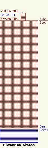
| Elevation Info |
Site Elevation: 679.5 meters (2229 ft) |
| Height of Structure: 48.7 meters (160 feet) |
| Overall Height Above Ground: 48.7 meters (160 feet) |
| Overall Height Above Mean Sea Level: 728.2 meters (2389 feet) |
| Owner Info | Virginia Department of State Police
7700 Midlothian Turnpike
27472
Richmond, VA 23261-7472
(804) 674-2044
Communications@vsp.virginia.gov |
| Contact Info | Virginia Department of State Police
7700 Midlothian Turnpike
27472
Richmond, VA 23261-7472
Richard Archer
(804) 674-4644
bruce.archer@vsp.virginia.gov |
