|
|
Antenna Structure Registration 1276304 |
 |
Registration Info | Registration Number: 1276304 |
| File Number: A0698403 |
| FAA Study: 2010-AGL-4633-OE |
| FAA Issue Date: 09/07/2010 |
| Status: Constructed |
| Date Constructed: 01/01/1979 |
| FAA EMI: N |
| NEPA: N |
Structure Info
| Structure Type: TOWER |
| Structure Coordinates: 43-57-8.1 N 86-17-9.8 W (NAD 83) |
| Structure Coordinates: 43-57-08.1 N 86-17-09.5 W (Converted to NAD 27) |
| Structure Address: 575 West First St. |
| Structure City: Scottville, MI |
| Structure County: Mason County |
| Painting & Lighting Info |
FCC Paragraph(s): 1, 3, 11, 21 |
Remarks: PRIOR STUDY 1991-AGL-298-OE |
Remarks: Continue As Is OM&L = PAINT/RED LIGHTS |
Remarks: PRIOR STUDY 1991-AGL-298-OE |
Remarks: Continue As Is OM&L = PAINT/RED LIGHTS |
| Elevation Info |
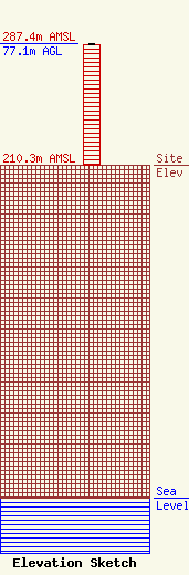
Site Elevation: 210.3 meters (690 ft) |
| Height of Structure: 76.2 meters (250 feet) |
| Overall Height Above Ground: 77.1 meters (253 feet) |
| Overall Height Above Mean Sea Level: 287.4 meters (943 feet) |
| Owner Info | City of Scottville
105 N. Main St.
Scottville, MI 49454
(231) 757-4729
|
| Contact Info | Carl E. Smith Consulting Engineers
2324 N. Cleveland-Massillon Rd.
807
Bath, OH 44210-0807
Roy Stype
(330) 659-4440
|
