|
|
Antenna Structure Registration 1280841 |
 |
Registration Info | Registration Number: 1280841 |
| File Number: A1150238 |
| FAA Study: 2011-AWP-1695-OE |
| FAA Issue Date: 06/10/2011 |
| Status: Constructed |
| Date Constructed: 12/30/2011 |
| FAA EMI: N |
| NEPA: N |
Structure Info
| Structure Type: POLE |
| Structure Coordinates: 37-54-38.0 N 121-13-37.4 W (NAD 83) |
| Structure Coordinates: 37-54-38.3 N 121-13-33.6 W (Converted to NAD 27) |
| Structure Address: 3136 Boeing Way |
| Structure City: Stockton, CA |
| Structure County: San Joaquin County |
| Painting & Lighting Info |
FAA Chapters: NONE |
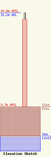
| Elevation Info |
Site Elevation: 9.7 meters (32 ft) |
| Height of Structure: 29 meters (95 feet) |
| Overall Height Above Ground: 31.1 meters (102 feet) |
| Overall Height Above Mean Sea Level: 40.8 meters (134 feet) |
| Owner Info | Cumulus Radio, LLC
3280 Peachtree Rd, Suite 2200
Atlanta, GA 30305
(404) 949-0700
towermanagement@cumulus.com |
| Contact Info | Cumulus Radio, LLC
2300 Vartan Way, Suite 130
Harrisburg, PA 17110
David Supplee
(717) 901-0720
dave.supplee@cumulus.com |
