|
|
Antenna Structure Registration 1282057 |
 |
Registration Info | Registration Number: 1282057 |
| File Number: A0746711 |
| FAA Study: 2011-ACE-2375-OE |
| FAA Issue Date: 12/15/2011 |
| Status: Constructed |
| Date Constructed: 12/29/2011 |
| FAA EMI: N |
| NEPA: N |
Structure Info
| Structure Type: TOWER |
| Structure Coordinates: 41-13-30.0 N 96-7-22.9 W (NAD 83) |
| Structure Coordinates: 41-13-30.0 N 96-07-21.8 W (Converted to NAD 27) |
| Structure Address: 13326 A Street |
| Structure City: Omaha, NE |
| Structure County: Douglas County |
| Painting & Lighting Info |
FAA Chapters: NONE |
Remarks: Removed expiration date from determination. Scenario 1./jjs/case#635066 |
| Elevation Info |
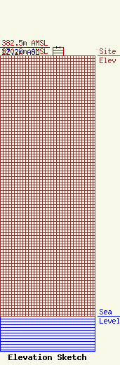
Site Elevation: 370.3 meters (1215 ft) |
| Height of Structure: 12.2 meters (40 feet) |
| Overall Height Above Ground: 12.2 meters (40 feet) |
| Overall Height Above Mean Sea Level: 382.5 meters (1255 feet) |
| Owner Info | VSS Catholic Communications, Inc.
13326 A Street
Omaha, NE 68144
(402) 871-0200
jimc@kvss.com |
