|
|
Antenna Structure Registration 1286277 |
 |
Registration Info | Registration Number: 1286277 |
| File Number: A1032733 |
| FAA Study: 2016-AWP-3659-OE |
| FAA Issue Date: 05/18/2016 |
| Status: Constructed |
| Date Constructed: 03/15/2007 |
| NEPA: N |
Structure Info
| Structure Type: MTOWER |
| Structure Coordinates: 19-25-56.8 N 155-15-35.6 W (NAD 83) |
| Structure Coordinates: 19-26-07.7 N 155-15-45.6 W (Converted to NAD 27) |
| Structure Address: 99-150 Crater Rim Dr - Hil03004 |
| Structure City: Pahoa, HI |
| Structure County: Hawaii County |
| Painting & Lighting Info |
FAA Chapters: NONE |
Remarks: PRIOR STUDY 2012-AWP-8727-OE |
| Elevation Info |
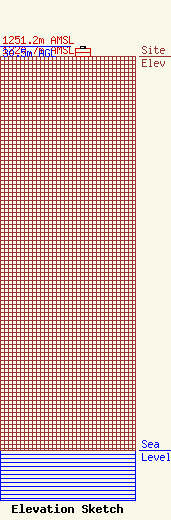
Site Elevation: 1220.7 meters (4005 ft) |
| Height of Structure: 24.7 meters (81 feet) |
| Overall Height Above Ground: 30.5 meters (100 feet) |
| Overall Height Above Mean Sea Level: 1251.2 meters (4105 feet) |
| Owner Info | CCATT LLC
2000 Corporate Drive
Canonsburg, PA 15317
(724) 416-2000
Regulatory.Department@Crowncastle.com |
| Contact Info | Crown Castle
2000 Corporate Drive
Canonsburg, PA 15317
Don Snyder
(724) 416-2470
Don.Snyder@crowncastle.com |
