|
|
Antenna Structure Registration 1286616 |
 |
Registration Info | Registration Number: 1286616 |
| File Number: A1194815 |
| FAA Study: 2012-AGL-9694-OE |
| FAA Issue Date: 11/15/2012 |
| Status: Constructed |
| Date Constructed: 10/12/2013 |
| FAA EMI: N |
| NEPA: N |
Structure Info
| Structure Type: GTOWER |
| Structure Coordinates: 43-54-27.0 N 99-41-47.0 W (NAD 83) |
| Structure Coordinates: 43-54-27.0 N 99-41-45.6 W (Converted to NAD 27) |
| Structure Address: 32348 241st St. |
| Structure City: Reliance, SD |
| Structure County: Lyman County |
| Painting & Lighting Info |
FAA Circular #: 70/7460-1K |
FAA Chapters: 3, 4, 5, 12 |
Remarks: PRIOR STUDY 2012-AGL-5813-OE. CHAPTERS 3,4,5,12 (1K). ADD SPECIAL CONDITION FOR LIGHTING DEVIATION. |
| Elevation Info |
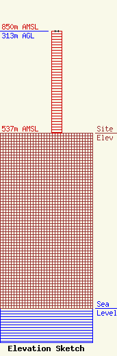
Site Elevation: 537 meters (1762 ft) |
| Height of Structure: 313 meters (1027 feet) |
| Overall Height Above Ground: 313 meters (1027 feet) |
| Overall Height Above Mean Sea Level: 850 meters (2789 feet) |
| Owner Info | Nexstar Media Inc.
545 E. John Carpenter Freeway
Irving, TX 75062
(972) 373-8800
jasroberts@nexstar.tv |
| Contact Info | Nexstar Media Inc.
545 E. John Carpenter Freeway
Irving, TX 75062
Jason Roberts
(972) 373-8800
jasroberts@nexstar.tv |
