|
|
Antenna Structure Registration 1287500 |
 |
Registration Info | Registration Number: 1287500 |
| File Number: A0927257 |
| FAA Study: 2013-AGL-5547-OE |
| FAA Issue Date: 09/19/2013 |
| Status: Constructed |
| Date Constructed: 11/19/2014 |
Structure Info
| Structure Type: LTOWER |
| Structure Coordinates: 41-30-12.1 N 81-38-38.1 W (NAD 83) |
| Structure Coordinates: 41-30-11.9 N 81-38-38.6 W (Converted to NAD 27) |
| Structure Address: 6555 Carnegie Avenue |
| Structure City: Cleveland, OH |
| Structure County: Cuyahoga County |
| Painting & Lighting Info |
FAA Circular #: 70/7460-1K |
FAA Chapters: 3, 4, 5, 12 |
Remarks: Removed final date from determination. Scenario 3./jjs/case#635066 |
Remarks: PRIOR STUDY 2012-AGL-9400-OE |
Remarks: Removed final date from determination. Scenario 3./jjs/case#635066 |
Remarks: PRIOR STUDY 2012-AGL-9400-OE |
| Elevation Info |
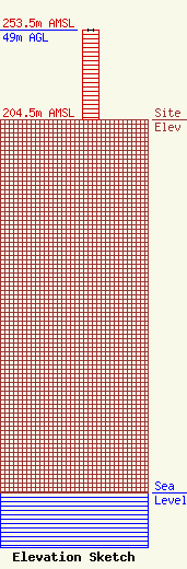
Site Elevation: 204.5 meters (671 ft) |
| Height of Structure: 49 meters (161 feet) |
| Overall Height Above Ground: 49 meters (161 feet) |
| Overall Height Above Mean Sea Level: 253.5 meters (832 feet) |
| Owner Info | Radio One Inc.
1010 Wayne Avenue
Silver Spring, MD 20910
(301) 429-3200
sharris@radio-one.com |
| Contact Info | Radio One Inc
1010 Wayne Avenue
Silver Spring, MD 20910
(301) 429-3254
gstrickland@radio-one.com |
