|
|
Antenna Structure Registration 1288606 |
 |
Registration Info | Registration Number: 1288606 |
| File Number: A0856628 |
| FAA Study: 2013-AGL-5484-OE |
| FAA Issue Date: 07/02/2013 |
| Status: Constructed |
| Date Constructed: 06/01/1998 |
| FAA EMI: N |
Structure Info
| Structure Type: LTOWER |
| Structure Coordinates: 39-59-9.2 N 83-3-53.2 W (NAD 83) |
| Structure Coordinates: 39-59-09.0 N 83-03-53.5 W (Converted to NAD 27) |
| Structure Address: 1458 Dublin Road |
| Structure City: Columbus, OH |
| Structure County: Franklin County |
| Painting & Lighting Info |
FAA Chapters: NONE |
| Elevation Info |
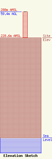
Site Elevation: 228.6 meters (750 ft) |
| Height of Structure: 59.4 meters (195 feet) |
| Overall Height Above Ground: 59.4 meters (195 feet) |
| Overall Height Above Mean Sea Level: 288 meters (945 feet) |
| Owner Info | North American Broadcasting Company, Inc.
1458 Dublin Road
Columbus, OH 43215
(614) 481-7800
bbowin@nabco-inc.com |
| Contact Info | North American Broadcasting Company, Inc.
1458 Dublin Road
Columbus, OH 43215
William Bowin
(614) 232-0271
bbowin@nabco-inc.com |
