|
|
Antenna Structure Registration 1291422 |
 |
Registration Info | Registration Number: 1291422 |
| File Number: A0970447 |
| FAA Study: 2013-AEA-5302-OE |
| FAA Issue Date: 01/06/2014 |
| Status: Constructed |
| Date Constructed: 01/10/2015 |
Structure Info
| Structure Type: LTOWER |
| Structure Coordinates: 38-20-42.0 N 75-35-48.0 W (NAD 83) |
| Structure Coordinates: 38-20-41.6 N 75-35-49.3 W (Converted to NAD 27) |
| Structure Address: Salisbury University |
| Structure City: Salisbury, MD |
| Structure County: Wicomico County |
| Painting & Lighting Info |
FAA Chapters: NONE |
Remarks: Removed expiration date from determination. Scenario 1./jjs/case#635066 |
| Elevation Info |
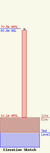
Site Elevation: 10.1 meters (33 ft) |
| Height of Structure: 59.4 meters (195 feet) |
| Overall Height Above Ground: 60.4 meters (198 feet) |
| Overall Height Above Mean Sea Level: 70.5 meters (231 feet) |
| Owner Info | Salisbury University
1101 Camden Avenue
Salisbury, MD 21801
(410) 543-6123
adstancil@salisbury.edu |
| Contact Info | Dewberry
600 Parsippany Road
Parsippany, NJ 07054
Corey Nachshen
(973) 576-9571
cnachshen@dewberry.com |
