|
|
Antenna Structure Registration 1292021 |
 |
Registration Info | Registration Number: 1292021 |
| File Number: A1313253 |
| FAA Study: 2025-AWP-4345-OE |
| FAA Issue Date: 04/28/2025 |
| Status: Constructed |
| Date Constructed: 06/16/1972 |
Structure Info
| Structure Type: LTOWER |
| Structure Coordinates: 32-53-31.3 N 116-25-10.6 W (NAD 83) |
| Structure Coordinates: 32-53-31.1 N 116-25-07.5 W (Converted to NAD 27) |
| Structure Address: Monument Pk, .5 Miles East Of Monument Peak Rd. (4469) |
| Structure City: Julian, CA |
| Structure County: San Diego County |
| Painting & Lighting Info |
FAA Chapters: NONE |
Remarks: PRIOR STUDY 2018-AWP-5443-OE |
| Elevation Info |
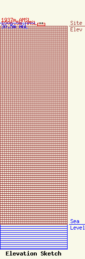
Site Elevation: 1906.5 meters (6255 ft) |
| Height of Structure: 28.3 meters (93 feet) |
| Overall Height Above Ground: 30.5 meters (100 feet) |
| Overall Height Above Mean Sea Level: 1937 meters (6355 feet) |
| Owner Info | American Towers LLC
10 Presidential Way
10 Presidential Way
Woburn, MA 01801
(781) 926-4500
faa-fcc@americantower.com |
| Contact Info | American Towers LLC
10 Presidential Way
10 Presidential Way
Woburn, MA 01801
(781) 926-4500
faa-fcc@americantower.com |
