|
|
Antenna Structure Registration 1292719 |
 |
Registration Info | Registration Number: 1292719 |
| File Number: A0937697 |
| FAA Study: 2014-ASO-4186-OE |
| FAA Issue Date: 05/12/2014 |
| Status: Constructed |
| Date Constructed: 02/08/2015 |
Structure Info
| Structure Type: LTOWER |
| Structure Coordinates: 33-13-0.7 N 87-31-26.1 W (NAD 83) |
| Structure Coordinates: 33-13-00.3 N 87-31-26.1 W (Converted to NAD 27) |
| Structure Address: 990 Campus Drive East |
| Structure City: Tuscaloosa, AL |
| Structure County: Tuscaloosa County |
| Painting & Lighting Info |
FAA Circular #: 70/7460-1K |
FAA Chapters: 4, 8, 12 |
Remarks: Removed expiration date from determination. Scenario 1./jjs/case#635066 |
| Elevation Info |
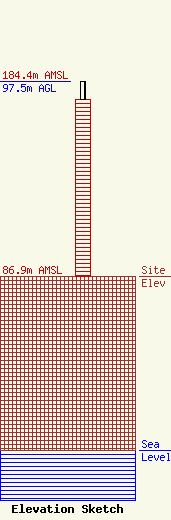
Site Elevation: 86.9 meters (285 ft) |
| Height of Structure: 88.5 meters (290 feet) |
| Overall Height Above Ground: 97.5 meters (320 feet) |
| Overall Height Above Mean Sea Level: 184.4 meters (605 feet) |
| Owner Info | The Board of Trustees of the University of Alabama
1110 Jackson Avenue
Tuscaloosa, AL 35487
(205) 347-1033
rranson@uapd.ua.edu |
| Contact Info | Fletcher, Heald & Hildreth, PLC
1300 NORTH 17TH STREET
ARLINGTON, VA 22209
(703) 812-4474
sjohnson@fhhlaw.com |
