|
|
Antenna Structure Registration 1292974 |
 |
Registration Info | Registration Number: 1292974 |
| File Number: A0932411 |
| FAA Study: 2014-ANM-129-NRA |
| FAA Issue Date: 07/23/2014 |
| Status: Constructed |
| Date Constructed: 09/01/2014 |
Structure Info
| Structure Type: LTOWER |
| Structure Coordinates: 42-22-19.3 N 122-52-45.8 W (NAD 83) |
| Structure Coordinates: 42-22-19.8 N 122-52-41.7 W (Converted to NAD 27) |
| Structure Address: 2070 Milligan Way |
| Structure City: Medford, OR |
| Structure County: Jackson County |
| Painting & Lighting Info |
FAA Chapters: NONE |
| Elevation Info |
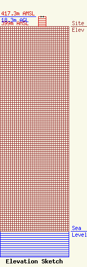
Site Elevation: 399 meters (1309 ft) |
| Height of Structure: 18.3 meters (60 feet) |
| Overall Height Above Ground: 18.3 meters (60 feet) |
| Overall Height Above Mean Sea Level: 417.3 meters (1369 feet) |
| Owner Info | UCB USA, Inc.
2070 Milligan Way
Medford, OR 97504
(541) 776-5368
perryatkinson@me.com |
| Contact Info | Hatfield & Dawson Consulting Engineers
9500 Greenwood Ave N
Seattle, WA 98103
Erik Swanson
(206) 783-9151
eswanson@hatdaw.com |
