|
|
Antenna Structure Registration 1293508 |
 |
Registration Info | Registration Number: 1293508 |
| File Number: A0924635 |
| FAA Study: 2014-ASO-9865-OE |
| FAA Issue Date: 10/14/2014 |
| Status: Constructed |
| Date Constructed: 06/01/1979 |
Structure Info
| Structure Type: GTOWER |
| Structure Coordinates: 36-37-21.7 N 83-42-45.6 W (NAD 83) |
| Structure Coordinates: 36-37-21.4 N 83-42-45.9 W (Converted to NAD 27) |
| Structure Address: N. 19th Street Extension |
| Structure City: Middlesboro, KY |
| Structure County: Bell County |
| Painting & Lighting Info |
FAA Chapters: NONE |
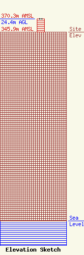
| Elevation Info |
Site Elevation: 345.9 meters (1135 ft) |
| Height of Structure: 24.4 meters (80 feet) |
| Overall Height Above Ground: 24.4 meters (80 feet) |
| Overall Height Above Mean Sea Level: 370.3 meters (1215 feet) |
| Owner Info | Gateway Broadcasting, Inc.
608
Middlesboro, KY 40965
(606) 248-5842
wmikradio@bellsouth.net |
| Contact Info | Gateway Broadcasting, Inc.
608
Middlesboro, KY 40965
(606) 248-5842
ceowens3@earthlink.net |
