|
|
Antenna Structure Registration 1296600 |
 |
Registration Info | Registration Number: 1296600 |
| File Number: A1085155 |
| FAA Study: 2015-AWP-221-OE |
| FAA Issue Date: 03/04/2015 |
| Status: Constructed |
| Date Constructed: 01/12/2016 |
Structure Info
| Structure Type: POLE |
| Structure Coordinates: 39-56-24.6 N 120-55-42.8 W (NAD 83) |
| Structure Coordinates: 39-56-25.0 N 120-55-39.0 W (Converted to NAD 27) |
| Structure Address: 1 Radio Hill Road |
| Structure City: Quincy, CA |
| Structure County: Plumas County |
| Painting & Lighting Info |
FAA Chapters: NONE |
Remarks: Removed expiration date from determination. Scenario 1./jjs/case#635066 |
| Elevation Info |
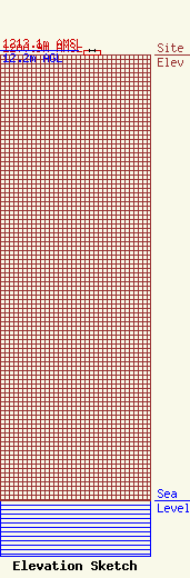
Site Elevation: 1200.9 meters (3940 ft) |
| Height of Structure: 12.2 meters (40 feet) |
| Overall Height Above Ground: 12.2 meters (40 feet) |
| Overall Height Above Mean Sea Level: 1213.1 meters (3980 feet) |
| Owner Info | Immaculate Heart Media, Inc.
1496 Bellevue Street
Green Bay, WI 54311
(920) 279-9054
adisterhaft@relevantradio.com |
| Contact Info | Smithwick & Belendiuk, P.C.
5028 Wisconsin Avenue, N.W.
Washington, DC 20016
Mark Denbo
(202) 350-9656
mdenbo@fccworld.com |
