|
|
Antenna Structure Registration 1297850 |
 |
Registration Info | Registration Number: 1297850 |
| File Number: A1050265 |
| FAA Study: 2015-AWP-1297-OE |
| FAA Issue Date: 03/06/2015 |
| Status: Constructed |
| Date Constructed: 06/20/2016 |
Structure Info
| Structure Type: LTOWER |
| Structure Coordinates: 37-22-33.4 N 121-54-37.1 W (NAD 83) |
| Structure Coordinates: 37-22-33.6 N 121-54-33.3 W (Converted to NAD 27) |
| Structure Address: 1940 Zanker Road |
| Structure City: San Jose, CA |
| Structure County: Santa Clara County |
| Painting & Lighting Info |
FAA Chapters: NONE |
Remarks: Removed expiration date from determination. Scenario 1./jjs/case#635066 |
| Elevation Info |
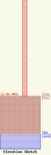
Site Elevation: 12.8 meters (42 ft) |
| Height of Structure: 45.7 meters (150 feet) |
| Overall Height Above Ground: 45.7 meters (150 feet) |
| Overall Height Above Mean Sea Level: 58.5 meters (192 feet) |
| Owner Info | KDTV LICENSE PARTNERSHIP, G.P.
5999 CENTER DRIVE SUITE 4083
Los Angeles, CA 90045
(310) 348-3600
cwood@Univision.net |
| Contact Info | Univision Television Group
5999 Center Drive
Los Angeles, CA 90045
Jeff Staigh
(310) 410-5652
jstaigh@univision.net |
