|
|
Antenna Structure Registration 1298081 |
 |
Registration Info | Registration Number: 1298081 |
| File Number: A1252275 |
| FAA Study: 2015-AEA-7738-OE |
| FAA Issue Date: 01/12/2016 |
| Status: Constructed |
| Date Constructed: 01/09/2017 |
Structure Info
| Structure Type: GTOWER |
| Structure Coordinates: 39-38-45.7 N 78-45-6.5 W (NAD 83) |
| Structure Coordinates: 39-38-45.4 N 78-45-07.4 W (Converted to NAD 27) |
| Structure Address: 350 Byrd Ave |
| Structure City: Cumberland, MD |
| Structure County: Allegany County |
| Painting & Lighting Info |
FAA Chapters: NONE |
| Elevation Info |
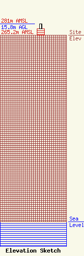
Site Elevation: 265.2 meters (870 ft) |
| Height of Structure: 9.1 meters (30 feet) |
| Overall Height Above Ground: 15.8 meters (52 feet) |
| Overall Height Above Mean Sea Level: 281 meters (922 feet) |
| Owner Info | Forever Media of MD, LLC
274 Lakemont Park Blvd
Altoona, PA 16602
(412) 951-1525
fcccontact@forevermediainc.com |
| Contact Info | Forever Media of MD, LLC
274 Lakemont Park Blvd
Altoona, PA 16602
(412) 951-1525
fcccontact@forevermediainc.com |
