|
|
Antenna Structure Registration 1313250 |
 |
Registration Info | Registration Number: 1313250 |
| File Number: A1165049 |
| FAA Study: 2019-ANM-8293-OE |
| FAA Issue Date: 12/13/2019 |
| Status: Constructed |
| Date Constructed: 01/01/1999 |
Structure Info
| Structure Type: LTOWER |
| Structure Coordinates: 45-41-29.3 N 118-51-9.1 W (NAD 83) |
| Structure Coordinates: 45-41-29.8 N 118-51-05.1 W (Converted to NAD 27) |
| Structure Address: 2003 Nw 56th Dr |
| Structure City: Pendleton, OR |
| Structure County: Umatilla County |
| Painting & Lighting Info |
FAA Chapters: NONE |
Remarks: PRIOR STUDY 2019-ANM-7262-OE |
| Elevation Info |
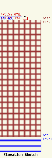
Site Elevation: 461.5 meters (1514 ft) |
| Height of Structure: 11.6 meters (38 feet) |
| Overall Height Above Ground: 14 meters (46 feet) |
| Overall Height Above Mean Sea Level: 475.5 meters (1560 feet) |
| Owner Info | EMG2, LLC
1009-C Adams Avenue
LA GRANDE, OR 97850
(541) 786-5223
RANDY@ELKHORNMEDIAGROUP.COM |
| Contact Info | Fletcher, Heald & Hildreth, PLC
1300 N. 17th St.
Arlington, VA 22209
MATTHEW MCCORMICK
(703) 812-0400
MCCORMICK@FHHLAW.COM |
