|
|
Antenna Structure Registration 1327928 |
 |
Registration Info | Registration Number: 1327928 |
| File Number: A1283796 |
| FAA Study: 2024-ANE-820-OE |
| FAA Issue Date: 04/04/2024 |
| Status: Constructed |
| Date Constructed: 05/13/2024 |
Structure Info
| Structure Type: GTOWER |
| Structure Coordinates: 43-40-50.4 N 70-22-42.5 W (NAD 83) |
| Structure Coordinates: 43-40-50.1 N 70-22-44.3 W (Converted to NAD 27) |
| Structure Address: Conant Street&highway 25 |
| Structure City: Westbrook, ME |
| Structure County: Cumberland County |
| Painting & Lighting Info |
FAA Chapters: NONE |
| Elevation Info |
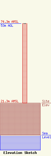
Site Elevation: 21.3 meters (70 ft) |
| Height of Structure: 53 meters (174 feet) |
| Overall Height Above Ground: 53 meters (174 feet) |
| Overall Height Above Mean Sea Level: 74.3 meters (244 feet) |
| Owner Info | Atlantic Coast Radio, LLC
779 Warren Avenue
Portland, ME 04103
(207) 773-9695
jon@atlanticcoastradio.com |
| Contact Info | Atlantic Coast Radio, LLC
779 Warren Avenue
Portland, ME 04103
Jon Van Hoogenstyn
(207) 773-9695
jon@atlanticcoastradio.com |
