|
|
Antenna Structure Registration 1002892 |
 |
Registration Info | Registration Number: 1002892 |
| File Number: A1085212 |
| FAA Study: 96-AGL-2639-OE |
| Status: Constructed |
| Date Constructed: 10/08/1996 |
| FAA EMI: N |
| NEPA: N |
Structure Info
| Structure Type: 3TA2 |
| Structure Coordinates: 44-47-2.0 N 93-20-39.0 W (NAD 83) |
| Structure Coordinates: 44-47-02.1 N 93-20-38.2 W (Converted to NAD 27) |
| Structure Address: .11 Mi N Of Sr13 .09 Mi E Of Vernon Ave |
| Structure City: Savage, MN |
| Structure County: Scott County |
| Painting & Lighting Info |
FAA Chapters: NONE |
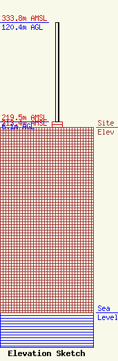
| Elevation Info |
Site Elevation: 213.4 meters (700 ft) |
| Height of Structure: 6.1 meters (20 feet) |
| Overall Height Above Ground: 120.4 meters (395 feet) |
| Overall Height Above Mean Sea Level: 333.8 meters (1095 feet) |
| Owner Info | Immaculate Heart Media, Inc.
1496 Bellevue Street
Green Bay, WI 54311
(920) 279-9054
adisterhaft@relevantradio.com |
| Contact Info | Smithwick & Belendiuk, P.C.
5028 Wisconsin Avenue, N.W.
Washington, DC 20016
Mark Denbo
(202) 350-9656
mdenbo@fccworld.com |
