|
|
Antenna Structure Registration 1003317 |
 |
Registration Info | Registration Number: 1003317 |
| File Number: A1208971 |
| FAA Study: 94-AEA-0328-OE |
| FAA Issue Date: 03/18/1994 |
| Status: Constructed |
| Date Constructed: 04/01/1993 |
| NEPA: N |
Structure Info
| Structure Type: LTOWER |
| Structure Coordinates: 40-50-32.0 N 73-2-23.0 W (NAD 83) |
| Structure Coordinates: 40-50-31.6 N 73-02-24.6 W (Converted to NAD 27) |
| Structure Address: 95 Lidge Dr., S Of Willow |
| Structure City: Farmingville, NY |
| Structure County: Suffolk County |
| Painting & Lighting Info |
FAA Circular #: 70/7460-1H |
FAA Chapters: 3, 4, 5, 13 |
| Elevation Info |
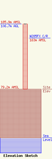
Site Elevation: 79.2 meters (260 ft) |
| Height of Structure: 106.7 meters (350 feet) |
| Overall Height Above Ground: 106.7 meters (350 feet) |
| Overall Height Above Mean Sea Level: 185.9 meters (610 feet) |
| W285FX C/R Height Above Mean Sea Level: 163 meters (535 ft)
|
| Owner Info | High-Tower Communications, Inc.
200 Woodland Avenue
Manorville, NY 11949
(631) 874-3558
WA2PJP@aol.com |
| Contact Info | High-Tower Communications, Inc.
200 Woodland Avenue
Manorville, NY 11949-2052
Joseph Rose
(631) 874-3558
WA2PJP@aol.com |
