|
|
Antenna Structure Registration 1003581 |
 |
Registration Info | Registration Number: 1003581 |
| File Number: A0936055 |
| FAA Study: 2014-ANE-2084-OE |
| FAA Issue Date: 01/20/2015 |
| Status: Constructed |
| Date Constructed: 01/01/1995 |
| NEPA: N |
Structure Info
| Structure Type: GTOWER |
| Structure Coordinates: 42-14-51.5 N 71-55-51.5 W (NAD 83) |
| Structure Coordinates: 42-14-51.2 N 71-55-53.2 W (Converted to NAD 27) |
| Structure Address: 650' North Of Intersection Of Main And Burncoat Streets |
| Structure City: Leicester, MA |
| Structure County: Worcester County |
| Painting & Lighting Info |
FCC Paragraph(s): 1, 3, 11, 21 |
Remarks: PRIOR STUDY 1999-ANE-354-OE |
Remarks: Continue As Is OM&L = PAINT/RED LIGHTS |
Remarks: PRIOR STUDY 1999-ANE-354-OE |
Remarks: Continue As Is OM&L = PAINT/RED LIGHTS |
| Elevation Info |
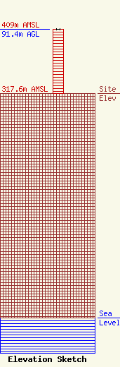
Site Elevation: 317.6 meters (1042 ft) |
| Height of Structure: 90.5 meters (297 feet) |
| Overall Height Above Ground: 91.4 meters (300 feet) |
| Overall Height Above Mean Sea Level: 409 meters (1342 feet) |
| Owner Info | CARTER BROADCASTING CORP
50 Braintree Hill Park
Braintree, MA 02184
(617) 423-0210
carterbroadcasting@gmail.com |
| Contact Info | Skywaves Consulting LLC
4
Millbury, MA 01527-0004
David Doherty
(401) 354-2400
dave@skywaves.com |
