|
|
Antenna Structure Registration 1003724 |
 |
Registration Info | Registration Number: 1003724 |
| File Number: A1094782 |
| FAA Study: 2016-AGL-12594-OE |
| FAA Issue Date: 12/09/2016 |
| Status: Constructed |
| Date Constructed: 05/07/1997 |
| NEPA: N |
Structure Info
| Structure Type: GTOWER |
| Structure Coordinates: 41-55-41.0 N 88-0-25.0 W (NAD 83) |
| Structure Coordinates: 41-55-40.9 N 88-00-24.8 W (Converted to NAD 27) |
| Structure Address: 700 West Moreland |
| Structure City: Addison, IL |
| Structure County: DuPage County |
| Painting & Lighting Info |
FAA Circular #: 70/7460-1L |
FAA Chapters: 3, 4, 5, 12 |
Remarks: PRIOR STUDY 1995-AGL-1028-OE |
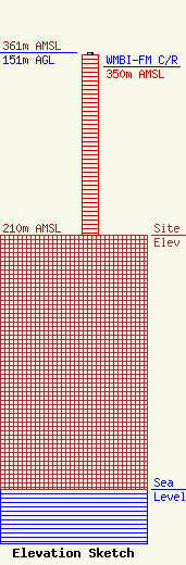
| Elevation Info |
Site Elevation: 210 meters (689 ft) |
| Height of Structure: 150 meters (492 feet) |
| Overall Height Above Ground: 151 meters (495 feet) |
| Overall Height Above Mean Sea Level: 361 meters (1184 feet) |
| WMBI-FM C/R Height Above Mean Sea Level: 350 meters (1148 ft)
|
| Owner Info | Moody Bible Institiute
820 LaSalle Blvd.
Chicago, IL 60610
(312) 329-4303
mark.williames@moody.edu |
| Contact Info | Moody Bible Institiute
820 LaSalle Blvd.
Chicago, IL 60610
(312) 329-4303
mark.williames@moody.edu |
