|
|
Antenna Structure Registration 1009012 |
 |
Registration Info | Registration Number: 1009012 |
| File Number: A1133190 |
| FAA Study: 2019-AGL-1804-OE |
| FAA Issue Date: 03/27/2019 |
| Status: Constructed |
| Date Constructed: 12/05/2002 |
| NEPA: N |
Structure Info
| Structure Type: BTWR |
| Structure Coordinates: 41-53-56.1 N 87-37-23.2 W (NAD 83) |
| Structure Coordinates: 41-53-56.0 N 87-37-23.0 W (Converted to NAD 27) |
| Structure Address: East Tower 875 N Michigan Ave (280282) |
| Structure City: Chicago, IL |
| Structure County: Cook County |
| Painting & Lighting Info |
FAA Circular #: 70/7460-1K |
FAA Chapters: 4, 8, 12 |
Remarks: OM&L to remain the same as prior study = A MED-DUAL SYSTEM |
Remarks: PRIOR STUDY 2018-AGL-10400-OE |
Remarks: OM&L to remain the same as prior study = A MED-DUAL SYSTEM |
Remarks: PRIOR STUDY 2018-AGL-10400-OE |
| Elevation Info |
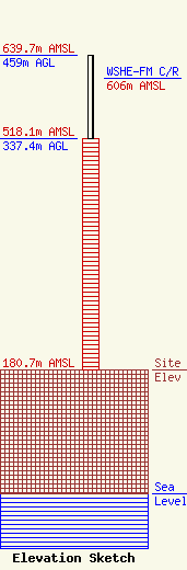
Site Elevation: 180.7 meters (593 ft) |
| Height of Structure: 337.4 meters (1107 feet) |
| Overall Height Above Ground: 459 meters (1506 feet) |
| Overall Height Above Mean Sea Level: 639.7 meters (2099 feet) |
| WSHE-FM C/R Height Above Mean Sea Level: 606 meters (1988 ft)
|
| Owner Info | American Towers LLC
10 Presidential Way
Woburn, MA 01801
(781) 926-4500
faa-fcc@americantower.com |
| Contact Info | American Towers LLC
10 Presidential Way
Woburn, MA 01801
(781) 926-4500
faa-fcc@americantower.com |
