|
|
Antenna Structure Registration 1011691 |
 |
Registration Info | Registration Number: 1011691 |
| File Number: A1085200 |
| FAA Study: 2009-AGL-6226-OE |
| FAA Issue Date: 11/19/2009 |
| Status: Constructed |
| Date Constructed: 01/01/1981 |
| FAA EMI: N |
| NEPA: N |
Structure Info
| Structure Type: 6TA5 |
| Structure Coordinates: 41-38-17.4 N 87-33-10.0 W (NAD 83) |
| Structure Coordinates: 41-38-17.3 N 87-33-09.8 W (Converted to NAD 27) |
| Structure Address: Twr 5 |
| Structure City: Burnham, IL |
| Structure County: Cook County |
| Painting & Lighting Info |
FCC Paragraph(s): 1, 3, 11, 21 |
Remarks: Continue As Is OM&L = PAINT/RED LIGHTS |
| Elevation Info |
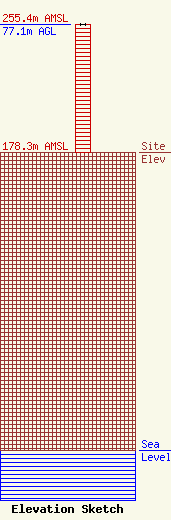
Site Elevation: 178.3 meters (585 ft) |
| Height of Structure: 77.1 meters (253 feet) |
| Overall Height Above Ground: 77.1 meters (253 feet) |
| Overall Height Above Mean Sea Level: 255.4 meters (838 feet) |
| Owner Info | Immaculate Heart Media, Inc.
1496 Bellevue Street
Green Bay, WI 54311
(920) 279-9054
adisterhaft@relevantradio.com |
| Contact Info | Smithwick & Belendiuk, P.C.
5028 Wisconsin Avenue, N.W.
Washington, DC 20016
Mark Denbo
(202) 350-9656
mdenbo@fccworld.com |
