|
|
Antenna Structure Registration 1014623 |
 |
Registration Info | Registration Number: 1014623 |
| File Number: A0360394 |
| FAA Study: 92-AWP-0414-OE |
| Status: Constructed |
| Date Constructed: 09/01/1989 |
| FAA EMI: N |
| NEPA: N |
Structure Info
| Structure Type: TOWER |
| Structure Coordinates: 39-12-20.0 N 121-49-14.0 W (NAD 83) |
| Structure Coordinates: 39-12-20.4 N 121-49-10.1 W (Converted to NAD 27) |
| Structure Address: S Peak Of Sutter Buttes |
| Structure City: Yuba City, CA |
| Structure County: Sutter County |
| Painting & Lighting Info |
FAA Circular #: 70/7460-1H |
FAA Chapters: 6, 13 |
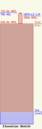
| Elevation Info |
Site Elevation: 638.8 meters (2096 ft) |
| Height of Structure: 73.1 meters (240 feet) |
| Overall Height Above Ground: 78 meters (256 feet) |
| Overall Height Above Mean Sea Level: 716.8 meters (2352 feet) |
| KEFM-LD C/R Height Above Mean Sea Level: 694 meters (2277 ft)
|
| Owner Info | TOR Broadcasting
50 Sunrise Blvd.
Colusa, CA 95932
(530) 458-2118
|
| Contact Info | TOR Broadcasting
50 Sunrise Blvd.
Colusa, CA 95932
Jake Kley
(530) 458-2118
|
