|
|
Antenna Structure Registration 1014800 |
 |
Registration Info | Registration Number: 1014800 |
| File Number: A0938287 |
| FAA Study: 2015-AWP-1082-OE |
| FAA Issue Date: 02/23/2015 |
| Status: Constructed |
| Date Constructed: 12/28/1960 |
| NEPA: N |
Structure Info
| Structure Type: LTOWER |
| Structure Coordinates: 34-17-47.0 N 119-16-24.0 W (NAD 83) |
| Structure Coordinates: 34-17-47.0 N 119-16-20.6 W (Converted to NAD 27) |
| Structure Address: (hall Canyon #89321--can) 3 Miles North Of East Main |
| Structure City: Ventura, CA |
| Structure County: Ventura County |
| Painting & Lighting Info |
FAA Circular #: 70/7460-1K |
FAA Chapters: 4, 8, 12 |
Remarks: PRIOR STUDY 2013-AWP-2119-OE |
Remarks: Removed expiration date from determination. Scenario 1./jjs/case#635066 |
Remarks: PRIOR STUDY 2013-AWP-2119-OE |
Remarks: Removed expiration date from determination. Scenario 1./jjs/case#635066 |
| Elevation Info |
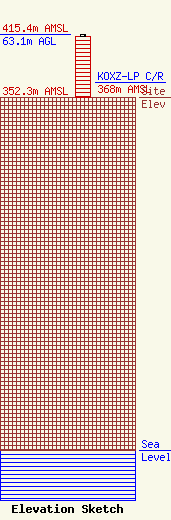
Site Elevation: 352.3 meters (1156 ft) |
| Height of Structure: 61 meters (200 feet) |
| Overall Height Above Ground: 63.1 meters (207 feet) |
| Overall Height Above Mean Sea Level: 415.4 meters (1363 feet) |
| KOXZ-LP C/R Height Above Mean Sea Level: 368 meters (1207 ft)
|
| Owner Info | American Towers LLC
10 Presidential Way
Woburn, MA 01801
(678) 564-3236
faa-fcc@americantower.com |
| Contact Info | American Towers, LLC.
10 Presidential Way
Woburn, MA 01801
(678) 564-3236
faa-fcc@americantower.com |
